


Urbanisation is a defining characteristic of the 21st century, particularly in Africa, which has the fastest rate of urbanisation in the world. Rapid development of cities across the continent is a major challenge for governments, demanding quick policy adaptation and infrastructure development. At its core, geospatial data represents a powerful a tool to support this transition.
With the global population expanding, and much of this growth expected to occur in African cities, nations will increasingly see emerging opportunities for economic development. Nevertheless, urbanisation also presents challenges as municipal governments pursue sustainable and equitable development, in line with the UN’s Sustainable Development Goals (SDGs).
While Africa is one of the least urbanised continents in the world today, by 2050, its cities will be home to an additional 950 million people. Driven by rapid economic changes and the fastest population growth in the world, in some African cities the majority of residents live in informal settlements such as slums and shanty towns. These informal settlements are often characterised by a lack of basic services and substandard housing. They also often mean insecure land tenure for the millions of people that live in them. Indeed, according to the World Bank, only 30 percent of the world’s population has legally registered rights to their land and homes.
So how can countries develop in a way that meets the SDGs, see economic returns, and in turn provide security to its citizens?
Geospatial data is a critical enabler for nations seeking to grow their economies, drive sustainable development, and support evidence-based decision making and policy setting. It will enable new and innovative uses of government data to solve problems and provide new infrastructure. Ordnance Survey has been working with authorities in Africa on pioneering projects that utilise the wealth of information and guidance that can be obtained through effective mapping.
More informed urban planning
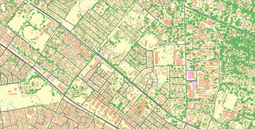
Urbanisation without sufficient oversight can lead to unregulated expansion of informal settlements, urban sprawl and degradation in the quality of civic life. The key to urban infrastructure that works is effective planning. That means ensuring new infrastructure is built in the right place, to the right capacity, and works well with other systems around it. Up-to-date digital records regarding population density and land use can give urban administrators better insights into where residents are and what they might need.
Cross-sector planning and decision-making, informed by geospatial data and implemented by effective governance, are the most powerful tools available to help municipal governments make a success of their city. Using consistent geospatial frameworks enables the ability to make decisions based on similar criteria and with access to similar types of information, at both national and local government levels.
There are significant financial benefits to addressing the challenges of urbanisation before informal settlements become large and unmanageable, which is why cities are increasingly the focus of government policy. Retrofitting infrastructure after a settlement has emerged is up to three times more expensive than installation alongside housing construction.
Fighting urban poverty
Geospatial data is the way forward for city governments to fight against urban poverty. It can help transform informal settlements into economically active parts of the city. Geospatial information empowers evidence-based policy and practice which is also the best way to prevent parts of cities that are growing fast becoming permanent informal settlements.
Zambia has recently started to draft the government’s first National Urbanisation Plan with the support of UN Habitat and The International Growth Centre (IGC). The Ministry of Local Government wanted to promote prosperous, inclusive and resilient urban settlements, and ensure Zambia’s towns and cities become engines of national growth.
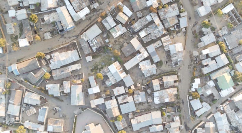
A collaboration between Ordnance Survey, the IGC and the Commonwealth Association of Architects (CAA) was established to respond to the issue of insufficient spatial data, by piloting the creation of an automated base map of Lusaka in Zambia, focusing on the identification of informal settlements. Currently, the base mapping in Zambia is not sufficiently up to date to provide a meaningful spatial data infrastructure foundation.
Using aerial imagery of Lusaka, Ordnance Survey generated a new base map using its advanced automated process which is faster and more resource efficient than traditional methods. The base map will provide a robust foundation for the integration of future census data and for a range of other functions including land administration. Together, this will enable the Ministry of Lands and the Zambian Government to better target investment in critical infrastructure and social services, upgrading informal settlements in order to provide for the most vulnerable city residents. Understanding key urbanisation trends is crucial for implementing and monitoring progress against the SDGs, including efforts to forge a new framework of urban development. Zambia has therefore taken a step forward in meeting these targets.
Using consistent geospatial frameworks in different cities, and in the rural areas between cities, allows the lessons learned locally to be applied in other areas and at a national level. Due to technological innovation, it is easier than ever before to maximise the value of location data and build a city’s geospatial capabilities. Geospatial innovation is accelerating at great speed, and it is now possible to build a digital base map in a fraction of the time and for a fraction of the cost of mapping efforts in the 20th century. Building location data capabilities can show how specific cities are used and how its citizens behave. Establishing a good baseline of geospatial maturity will help make informed policy decisions and help demonstrate the results of those decisions to citizens and investors.
Every country is at a different stage of their approach to managing geospatial information. ‘Geospatial maturity’ is a term used to describe the level of sophistication that a country has in its ability to collect, manage and exploit geospatial information for the benefit of the nation. Ordnance Survey offers free geospatial maturity assessments, which is a tool that can help governments objectively understand how mature their geospatial capabilities are.
It is now easier and quicker than ever to build a country’s geospatial data capabilities. Ordnance Survey has 200 years of expertise as Britain’s national mapping agency, which, when combined with the speed and usability of modern technological innovation, can deliver a solution that harnesses a city’s potential. Ordnance Survey’s centuries of practice in building base maps that underpin growth and empower communities can help countries establish their own data capabilities, giving governments the tools needed for sustainable development.
Read the report on building prosperous, sustainable and fairer cities with geospatial data.
